


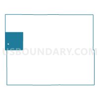
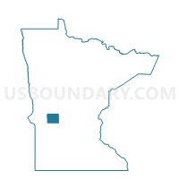
New Prairie Twp. Voting District, Pope County, Minnesota
About
Outline

Summary
| Unique Area Identifier | 603771 |
| Name | New Prairie Twp. Voting District |
| County | Pope County |
| State | Minnesota |
| Area (square miles) | 35.81 |
| Land Area (square miles) | 35.23 |
| Water Area (square miles) | 0.58 |
| % of Land Area | 98.38 |
| % of Water Area | 1.62 |
| Latitude of the Internal Point | 45.63626000 |
| Longtitude of the Internal Point | -95.68644260 |
Maps

Graphs
Select a template below for downloading or customizing gragh for New Prairie Twp. Voting District, Pope County, Minnesota


Neighbors
Neighoring Voting District (by Name) Neighboring Voting District on the Map
- Ben Wade Twp. Voting District, Pope County, MN
- Cyrus Voting District, Pope County, MN
- Framnas Twp. Voting District, Stevens County, MN
- Hodges Twp. Voting District, Stevens County, MN
- Nora Twp. Voting District, Pope County, MN
- Swan Lake Twp. Voting District, Stevens County, MN
- Walden Twp. Voting District, Pope County, MN
- White Bear Lake Twp. Voting District, Pope County, MN
Top 10 Neighboring County Subdivision (by Population) Neighboring County Subdivision on the Map
- White Bear Lake township, Pope County, MN (431)
- Framnas township, Stevens County, MN (305)
- Cyrus city, Pope County, MN (288)
- Hodges township, Stevens County, MN (277)
- Ben Wade township, Pope County, MN (250)
- Nora township, Pope County, MN (205)
- New Prairie township, Pope County, MN (197)
- Swan Lake township, Stevens County, MN (194)
- Walden township, Pope County, MN (169)